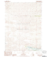
1985 Map of Kennedy NW
USGS Topo · Published 1985About this map
Samuel R Mc Kelvie National Forest dominates this mid-1980s landscape in Cherry County, Nebraska, showing a vast area of protected sandhills terrain. The map centers on the winding course of Steer Creek, which flows eastward through the forest toward the Merritt Reservoir. This 1985 provisional edition captures the transition from the open valley of Powderhorn Valley into the managed recreation and wildlife areas of the eastern quadrangle. Local landmarks such as the Steer Creek Camp suggest the area's use for outdoor recreation, while the Merritt Reservoir State Wildlife Management Area underscores the importance of water management and habitat preservation in this specific corner of the Nebraska panhandle.
Find a feature on this map
7 named features on this map. Tap any name to fly to it.
Don’t see what you’re looking for? This feature index may not catch every label — zoom into the map to look around manually.
Map Details
Editions of this 1985 Kennedy NW Map
This is the sole edition of this map. No revisions or reprints were ever made.
Other maps of this area

1950 · Powderhorn Valley
USGS Topo · 1:62,500

1950 · Kennedy
USGS Topo · 1:62,500

1950 · Kilgore
USGS Topo · 1:62,500

1950 · Cody
USGS Topo · 1:62,500

1957 · Valentine
USGS Topo · 1:250,000

1959 · Valentine
USGS Topo · 1:250,000
1985 · Kilgore SE
USGS Topo · 1:24,000

1985 · Cooper Canyon
USGS Topo · 1:24,000
1985 · Cody SE
USGS Topo · 1:24,000

1985 · Cody
USGS Topo · 1:100,000