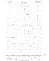
1974 Map of Kennedy SE
USGS Topo · Published 1976About this map
Spring Brook winds through the agricultural landscape of Kittson and Marshall Counties, anchoring a region defined by its meticulous drainage network. This 1974 survey details the intersection of Davis, Sinnott, and Augsburg townships, where the flat terrain is managed by an extensive system of waterways including Judicial Ditch No 6 and County Ditch No 4. Local landmarks such as Andreason Lake and several scattered Gravel Pits break the patterned fields, reflecting the rural utility of the era.
Find a feature on this map
19 named features on this map. Tap any name to fly to it.
Don’t see what you’re looking for? This feature index may not catch every label — zoom into the map to look around manually.
Map Details
Editions of this 1974 Kennedy SE Map
This is the sole edition of this map. No revisions or reprints were ever made.
Other maps of this area

1918 · Argyle
USGS Topo · 1:62,500

1939 · Kennedy
USGS Topo · 1:62,500

1941 · Kennedy
USGS Topo · 1:62,500

1952 · Thief River Falls
USGS Topo · 1:250,000

1954 · Stephen
USGS Topo · 1:62,500

1956 · Thief River Falls
USGS Topo · 1:250,000

1956 · Karlstad
USGS Topo · 1:62,500

1956 · Florian
USGS Topo · 1:62,500

1957 · Thief River Falls
USGS Topo · 1:250,000

1967 · Thief River Falls
USGS Topo · 1:250,000