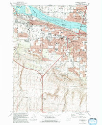
1992 Map of Kennewick
USGS Topo · Published 1992About this map
Lake Wallula and the Columbia River dominate this landscape during a period of significant suburban expansion in the Tri-Cities area. The confluence of the Yakima River near Bateman Island anchors the northern boundary, where the river's edge is lined with parks such as Hawthorne Park and the Riverview Natural Preserve. As the community of Kennewick pushes south and west into the Highlands, the map reveals a maturing infrastructure of education and community life, evidenced by Kamiakin High Sch, Desert Hills Middle Sch, and the Desert Lawn Memorial Park cemetery.
Find a feature on this map
78 named features on this map. Tap any name to fly to it.
Don’t see what you’re looking for? This feature index may not catch every label — zoom into the map to look around manually.
Map Details
Editions of this 1992 Kennewick Map
This is the sole edition of this map. No revisions or reprints were ever made.
Other maps of this area

1917 · Pasco
USGS Topo · 1:125,000

1951 · Richland
USGS Topo · 1:62,500

1953 · Walla Walla
USGS Topo · 1:250,000

1958 · Walla Walla
USGS Topo · 1:250,000
1964 · Johnson Butte
USGS Topo · 1:24,000
1964 · Nine Canyon
USGS Topo · 1:24,000

1964 · Kennewick
USGS Topo · 1:24,000

1964 · Pasco
USGS Topo · 1:62,500
1964 · Pasco
USGS Topo · 1:24,000

1965 · Eltopia
USGS Topo · 1:62,500