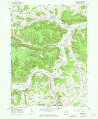
1954 Map of Kenneyville
USGS Topo · Published 1971About this map
The northern reaches of the Borough Boundary for Wellsboro define the southern edge of this mid-century landscape, where the confluence of several valleys creates a corridor for the Penn Central railroad. Following the curves of Marsh Creek and Crooked Creek, the rail line links a series of small settlements including Stokesdale, Wellsboro Junction, and Niles Valley. The terrain is marked by numerous timber and transport routes such as Bark Slide Trail and Plantation Trail, which snake through the hollows of Oak Ridge. Local life in the 1950s is anchored by rural institutions like the Marsh Creek Sch and the Middlebury Union Cem. The map reveals a transition in land use, noting a Gas Well and the Pipeline Road alongside family landmarks like Barlow Hill and Horse Thief Run, documenting the enduring rural character of Tioga County before later modern development.
Find a feature on this map
67 named features on this map. Tap any name to fly to it.
Don’t see what you’re looking for? This feature index may not catch every label — zoom into the map to look around manually.
Map Details
Editions of this 1954 Kenneyville Map
3 editions found
Other maps of this area

1900 · Tioga
USGS Topo · 1:62,500

1900 · Elkland
USGS Topo · 1:62,500

1902 · Tioga
USGS Topo · 1:62,500

1925 · Blossburg
USGS Topo · 1:62,500

1927 · Blossburg
USGS Topo · 1:62,500

1944 · Blossburg
USGS Topo · 1:62,500

1946 · Tiadaghton
USGS Topo · 1:24,000

1946 · Antrim
USGS Topo · 1:62,500

1946 · Antrim
USGS Topo · 1:24,000

1948 · Antrim
USGS Topo · 1:24,000
Featured Places
- Wellsboro, PA
- Stokesdale, Delmar Township
- Keeneyville, Middlebury Township
- Shortsville, Chatham Township
- Middlebury Township, PA