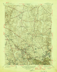
1945 Map of Kensington
USGS Topo · Published 1945About this map
Kensington serves as a central hub in this mid-1940s landscape, where the Baltimore and Ohio RR cuts through the suburbanizing hills of Montgomery County. The transition from agricultural land to residential developments is evident in the cluster of neighborhoods like Chevy Chase View, Garrett Park, and Wheaton. Significant institutional footprints are established at the Naval Medical Center and the National Institute of Health, while the Georgetown Preparatory School and Montgomery Blair High Sch anchor local education. Genealogy researchers can locate several family and community burial grounds, including the St Marys Cem and Beall Cem. The landscape is defined by the winding course of Rock Creek and the Northwest Branch, which are surrounded by early recreation sites like the Manor Country Club and Argyle Country Club.
Find a feature on this map
94 named features on this map. Tap any name to fly to it.
Don’t see what you’re looking for? This feature index may not catch every label — zoom into the map to look around manually.
Map Details
Editions of this 1945 Kensington Map
3 editions found
Other maps of this area

1890 · Mt. Vernon
USGS Topo · 1:125,000

1891 · Mt. Vernon
USGS Topo · 1:125,000

1892 · Laurel
USGS Topo · 1:62,500

1893 · Frederick
USGS Topo · 1:125,000

1894 · Laurel
USGS Topo · 1:62,500

1894 · Frederick
USGS Topo · 1:125,000

1894 · Mt. Vernon
USGS Topo · 1:125,000

1897 · Laurel
USGS Topo · 1:62,500

1897 · Mt. Vernon
USGS Topo · 1:125,000

1899 · Patuxent
USGS Topo · 1:125,000