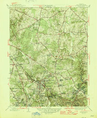
1945 Map of Kensington
USGS Topo · Published 1945About this map
The suburban landscape of Montgomery County transitions from the dense street grids of Silver Spring and Kensington toward the rolling rural reaches of Norbeck and Colesville. Just before the post-war housing boom fundamentally reshaped the region, this 1945 survey documents a mix of agricultural heritage and early institutional growth. Large estates and country clubs, such as the Manor Country Club and Indian Spring Golf Club, occupy significant acreage alongside emerging residential developments like Indian Spring Village and Northbrooks Estates.
Find a feature on this map
84 named features on this map. Tap any name to fly to it.
Don’t see what you’re looking for? This feature index may not catch every label — zoom into the map to look around manually.
Map Details
Editions of this 1945 Kensington Map
3 editions found
Other maps of this area

1890 · Mt. Vernon
USGS Topo · 1:125,000

1891 · Mt. Vernon
USGS Topo · 1:125,000

1892 · Laurel
USGS Topo · 1:62,500

1893 · Frederick
USGS Topo · 1:125,000

1894 · Laurel
USGS Topo · 1:62,500

1894 · Frederick
USGS Topo · 1:125,000

1894 · Mt. Vernon
USGS Topo · 1:125,000

1897 · Laurel
USGS Topo · 1:62,500

1897 · Mt. Vernon
USGS Topo · 1:125,000

1899 · Patuxent
USGS Topo · 1:125,000