
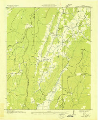
1936 Map of Kensington
USGS Topo · Published 1936About this map
Chickamauga and the surrounding Walker County countryside are captured here in 1936, just as the Tennessee Valley Authority was actively surveying the region's complex topography. The map reveals a landscape defined by significant ridges like Missionary Ridge and the heights of Pigeon Mountain, which drop into the Blue Basin. Industrial and infrastructure development of the era is evident in the presence of the Tennessee Power Company Transmission Line and a series of flumes. Local life centers on rural nodes such as Pond Spring and Kensington, supported by neighborhood institutions like the Oak Grove Sch, Bethel Ch, and the Hill Mill. The drainage of West Chickamauga Creek and its many branches provides a detailed look at the water sources that dictated the placement of early homesteads and cemeteries like Lawrence Cem.
Find a feature on this map
60 named features on this map. Tap any name to fly to it.
Don’t see what you’re looking for? This feature index may not catch every label — zoom into the map to look around manually.
Map Details
Editions of this 1936 Kensington Map
This is the sole edition of this map. No revisions or reprints were ever made.
Other maps of this area

1886 · Ringgold
USGS Topo · 1:125,000

1892 · Ringgold
USGS Topo · 1:125,000

1935 · Catlett
USGS Topo · 1:24,000

1935 · East Ridge
USGS Topo · 1:24,000

1935 · Durham
USGS Topo · 1:24,000

1935 · Nickajack Gap
USGS Topo · 1:24,000

1936 · Hooker
USGS Topo · 1:24,000

1936 · Estelle
USGS Topo · 1:24,000

1936 · Fort Oglethorpe
USGS Topo · 1:24,000
1936 · Cedar Grove
USGS Topo · 1:24,000