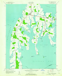
1942 Map of Kent Island
USGS Topo · Published 1961About this map
Stevensville and Chester anchor the northern landscape of Kent Island in this 1942 survey, reflecting a maritime community deeply connected to the mainland via the Baltimore and Eastern RR and the Annapolis Ferry. The map captures a detailed snapshot of the island's mid-century infrastructure, where small settlements like Dominion and Matapeake are linked by rural roads and coastal commerce. The interior and shorelines are dotted with community landmarks, including Wesley Ch, Kingsley Ch, and the Batts Neck Sch. Deep tidal inlets such as Cox Creek and Crab Alley Creek carve into the land, defining the agricultural and fishing reaches of Batts Neck. This survey preserves the island’s geography before the completion of the first Chesapeake Bay Bridge altered its traditional transit patterns, documenting the vital roles of points like Romancoke and the Claiborne Ferry.
Find a feature on this map
45 named features on this map. Tap any name to fly to it.
Don’t see what you’re looking for? This feature index may not catch every label — zoom into the map to look around manually.
Map Details
Editions of this 1942 Kent Island Map
3 editions found
Other maps of this area

1892 · Annapolis
USGS Topo · 1:62,500

1893 · North Point
USGS Topo · 1:62,500

1898 · Choptank
USGS Topo · 1:125,000

1898 · Tolchester
USGS Topo · 1:125,000

1901 · Chestertown
USGS Topo · 1:62,500

1903 · Tolchester
USGS Topo · 1:125,000

1904 · St. Michaels
USGS Topo · 1:62,500

1904 · North Point
USGS Topo · 1:62,500

1904 · Annapolis
USGS Topo · 1:62,500

1908 · Tolchester
USGS Topo · 1:125,000