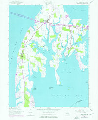
1942 Map of Kent Island
USGS Topo · Published 1976About this map
Kent Island is defined by its intricate network of tidal creeks and fingers of land reaching into the Chesapeake Bay. The 1942 topography reveals a largely rural landscape punctuated by small communities like Stevensville and Chester. Transportation across the bay is anchored by the William Preston Lane Jr Memorial Bridge, which connects the island to the mainland.
Find a feature on this map
47 named features on this map. Tap any name to fly to it.
Don’t see what you’re looking for? This feature index may not catch every label — zoom into the map to look around manually.
Map Details
Editions of this 1942 Kent Island Map
3 editions found
Other maps of this area

1892 · Annapolis
USGS Topo · 1:62,500

1893 · North Point
USGS Topo · 1:62,500

1898 · Choptank
USGS Topo · 1:125,000

1898 · Tolchester
USGS Topo · 1:125,000

1901 · Chestertown
USGS Topo · 1:62,500

1903 · Tolchester
USGS Topo · 1:125,000

1904 · St. Michaels
USGS Topo · 1:62,500

1904 · North Point
USGS Topo · 1:62,500

1904 · Annapolis
USGS Topo · 1:62,500

1908 · Tolchester
USGS Topo · 1:125,000