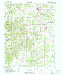
1956 Map of Kent
USGS Topo · Published 1994About this map
Kent and Lexington anchor this mid-century look at the borderlands of Scott and Jefferson Counties, where the drainage of Fourteenmile Creek and Caney Fork carves through the Indiana landscape. The settlement pattern is defined by small agricultural hubs and a network of rural institutions that served these scattered farmsteads. Local history is preserved in the numerous cemeteries dotting the hills, such as Slippery Point Cem and Blankenship Cem, alongside country churches like New Bethel Ch. Natural landmarks like Morris Cave and the Big Springs area suggest a karst topography common to this region of Southern Indiana. The presence of Pleasant Point Sch and the community at Swanville show a landscape of established crossroads connected by the winding routes of Ind. 256 and Ind. 356.
Find a feature on this map
39 named features on this map. Tap any name to fly to it.
Don’t see what you’re looking for? This feature index may not catch every label — zoom into the map to look around manually.
Map Details
Editions of this 1956 Kent Map
4 editions found
Other maps of this area

1939 · Bethlehem
USGS Topo · 1:24,000

1939 · Madison West
USGS Topo · 1:24,000

1948 · Bethlehem
USGS Topo · 1:24,000

1948 · Madison West
USGS Topo · 1:24,000

1953 · Madison West
USGS Topo · 1:24,000

1953 · Bethlehem
USGS Topo · 1:24,000

1956 · Otisco
USGS Topo · 1:24,000

1956 · Volga
USGS Topo · 1:24,000

1956 · Blocher
USGS Topo · 1:24,000

1956 · Kent
USGS Topo · 1:24,000