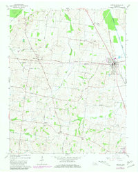
1965 Map of Kenton
USGS Topo · Published 1981About this map
The Obion and Gibson County line bisects this West Tennessee landscape, where the Rutherford Fork Obion River and the Obion River define the local drainage. In the mid-1960s, the area remained deeply agricultural, anchored by the incorporated towns of Kenton and Rutherford, along with numerous rural crossroads and farming communities. A network of rural churches and cemeteries, such as Bethpage Ch and Sunny Side Cem, illustrates the deep-rooted social fabric of the region. The map captures an era of infrastructure development, shown through the presence of several pipelines and the established Gulf Central Illinois Road. To the northwest, the Gooch Waterfowl Management Area preserves the low-lying wetlands near Turtle Bend, contrasting with the more developed upland areas around Mason Hall and Tilghman.
Find a feature on this map
55 named features on this map. Tap any name to fly to it.
Don’t see what you’re looking for? This feature index may not catch every label — zoom into the map to look around manually.
Map Details
Editions of this 1965 Kenton Map
2 editions found
Other maps of this area

1950 · Obion
USGS Topo · 1:24,000

1950 · Rives
USGS Topo · 1:24,000

1951 · Obion
USGS Topo · 1:24,000

1951 · Rives
USGS Topo · 1:24,000

1953 · Dyer
USGS Topo · 1:24,000

1954 · Rutherford
USGS Topo · 1:24,000

1956 · Gardner
USGS Topo · 1:24,000

1956 · Dyersburg
USGS Topo · 1:250,000
1964 · Yorkville
USGS Topo · 1:24,000
1965 · Kenton
USGS Topo · 1:24,000