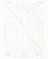
1972 Map of Keota
USGS Topo · Published 1975About this map
The high plains of Weld County center on the small settlement of Keota, shown here in the early 1970s. The town's layout is clearly defined against the surrounding agricultural landscape, featuring a Water Tank and its proximity to the Burlington Northern railroad line that cuts diagonally across the quadrangle. This transportation corridor was historically vital for moving livestock and grain from this corner of Colorado. To the north, a small Cem serves the local community, while the drainage of Wild Horse Creek and the man-made Wild Horse Reservoir indicate the critical importance of water management in this arid region. Scattered across the sections are numerous notations for wells, including an Oil Well in the south, reflecting the area's dual reliance on ranching and emerging energy extraction.
Find a feature on this map
10 named features on this map. Tap any name to fly to it.
Don’t see what you’re looking for? This feature index may not catch every label — zoom into the map to look around manually.
Map Details
Editions of this 1972 Keota Map
2 editions found
Other maps of this area

1954 · Sterling
USGS Topo · 1:250,000

1954 · Greeley
USGS Topo · 1:250,000

1957 · Greeley
USGS Topo · 1:250,000

1958 · Greeley
USGS Topo · 1:250,000

1958 · Sterling
USGS Topo · 1:250,000

1961 · Greeley
USGS Topo · 1:250,000

1964 · Greeley
USGS Topo · 1:250,000

1965 · Greeley
USGS Topo · 1:250,000

1972 · Dutch Girl Lake
USGS Topo · 1:24,000
1972 · Keota SE
USGS Topo · 1:24,000