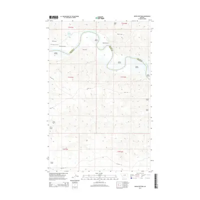
2014 Map of Kepple Bottoms
USGS Topo · Published 2014About this map
The Missouri River carves a dramatic northern boundary across this landscape, defining the border between Fergus and Phillips counties. Along its banks, several named lowlands or "bottoms" illustrate the geography of the river valley, including Manning Bottoms, Kepple Bottoms, and Withro Bottoms. These flat alluvial areas are punctuated by Rocky Point, where the terrain shifts from the river's edge toward the surrounding ridges. To the northwest, the Rock Cr Reservoir provides a significant water source, feeding into Rock Creek. The map reveals a network of paths for modern and traditional travel, from the Rock Creek Boat Ramp Rd to several historic routes like the Wilder Trl and Musselshell Trl, which navigate the complex system of draws and drainages such as Carroll Coulee.
Find a feature on this map
28 named features on this map. Tap any name to fly to it.
Don’t see what you’re looking for? This feature index may not catch every label — zoom into the map to look around manually.
Map Details
Editions of this 2014 Kepple Bottoms Map
This is the sole edition of this map. No revisions or reprints were ever made.
Other maps of this area

1943 · Landusky
USGS Topo · 1:125,000

1954 · Bell Ridge East
USGS Topo · 1:24,000

1954 · Carter Coulee
USGS Topo · 1:24,000

1954 · Lewistown
USGS Topo · 1:250,000

1959 · Lewistown
USGS Topo · 1:250,000

1971 · Blizzard Reservoir
USGS Topo · 1:24,000

1971 · Kepple Bottoms
USGS Topo · 1:24,000
1971 · Sagebrush Reservoir
USGS Topo · 1:24,000

1971 · Hanson Flat
USGS Topo · 1:24,000

1984 · Zortman
USGS Topo · 1:100,000