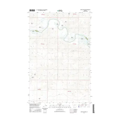
2017 Map of Kepple Bottoms
USGS Topo · Published 2017About this map
The Missouri River meanders sharply through the boundary of Phillips and Fergus Counties, carving out a series of alluvial flats that defined the ranching and geographical character of this Montana landscape. These named tracts, including Kepple Bottoms, Manning Bottoms, and Turner Bottoms, represent the primary habitable areas between the river's edge and the rising Breaks.
Find a feature on this map
24 named features on this map. Tap any name to fly to it.
Don’t see what you’re looking for? This feature index may not catch every label — zoom into the map to look around manually.
Map Details
Editions of this 2017 Kepple Bottoms Map
This is the sole edition of this map. No revisions or reprints were ever made.
Other maps of this area

1943 · Landusky
USGS Topo · 1:125,000

1954 · Bell Ridge East
USGS Topo · 1:24,000

1954 · Carter Coulee
USGS Topo · 1:24,000

1954 · Lewistown
USGS Topo · 1:250,000

1959 · Lewistown
USGS Topo · 1:250,000

1971 · Blizzard Reservoir
USGS Topo · 1:24,000

1971 · Kepple Bottoms
USGS Topo · 1:24,000
1971 · Sagebrush Reservoir
USGS Topo · 1:24,000

1971 · Hanson Flat
USGS Topo · 1:24,000

1984 · Zortman
USGS Topo · 1:100,000