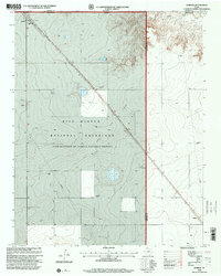
1998 Map of Kerrick
USGS Topo · Published 2001About this map
Rita Blanca National Grassland dominates this corner of the Texas Panhandle, where the high plains meet the Oklahoma border. The small settlement of Kerrick serves as a focal point in the northwest, situated along the tracks of the Burlington Northern Santa Fe railroad. This landscape is a working environment of energy extraction and grain storage, characterized by a sprawling Oil and Gas Field and scattered Oil Wells.
Find a feature on this map
15 named features on this map. Tap any name to fly to it.
Don’t see what you’re looking for? This feature index may not catch every label — zoom into the map to look around manually.
Map Details
Editions of this 1998 Kerrick Map
This is the sole edition of this map. No revisions or reprints were ever made.
Other maps of this area

1954 · Dalhart
USGS Topo · 1:250,000

1958 · Dalhart
USGS Topo · 1:250,000

1962 · Dalhart
USGS Topo · 1:250,000

1964 · Brickel
USGS Topo · 1:24,000

1964 · Kerrick
USGS Topo · 1:24,000

1964 · Stratford 2 SE
USGS Topo · 1:24,000

1964 · Stratford 2 NE
USGS Topo · 1:24,000

1964 · Stratford
USGS Topo · 1:24,000

1964 · Stratford NE
USGS Topo · 1:24,000

1971 · Griggs SW
USGS Topo · 1:24,000