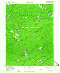
1957 Map of Keswick Grove
USGS Topo · Published 1961About this map
Cranberry Bogs define the industrial and agricultural character of this New Jersey landscape, which spans parts of Manchester, Dover, and Berkeley townships. The map documents a significant intersection of transportation history, showing the Central Railroad of New Jersey and the Pennsylvania Railroad cutting through the Pine Barrens alongside an Old Railroad Grade. Small settlements like Keswick Grove and Cedar Crest are isolated by a dense network of water bodies, including Bamber Lake, Keswick Lake, and numerous branches of Cedar Creek. Cultural landmarks such as the William Raws Monument and the Park Rod and Gun Club reflect the local social history, while the John Davison Rockefeller Memorial Highway provides a major arterial through the wooded terrain. This 1957 field-checked survey reveals an era before suburban expansion, where the economy was still deeply tied to the specific hydrology of the Cedar Swamp.
Find a feature on this map
40 named features on this map. Tap any name to fly to it.
Don’t see what you’re looking for? This feature index may not catch every label — zoom into the map to look around manually.
Map Details
Editions of this 1957 Keswick Grove Map
Other maps of this area

1884 · Whitings
USGS Topo · 1:62,500

1888 · Barnegat
USGS Topo · 1:62,500

1888 · Asbury Park
USGS Topo · 1:62,500

1888 · Cassville
USGS Topo · 1:62,500

1888 · Whitings
USGS Topo · 1:62,500

1893 · Asbury Park
USGS Topo · 1:62,500

1893 · Barnegat
USGS Topo · 1:62,500

1894 · Cassville
USGS Topo · 1:62,500

1898 · Barnegat
USGS Topo · 1:62,500

1900 · Cassville
USGS Topo · 1:62,500
Featured Places
- Toms River, NJ
- Manchester Township, NJ
- Berkeley Township, NJ
- Lacey Township, NJ
- Crestwood Village, Manchester Township