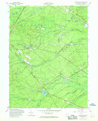
1957 Map of Keswick Grove
USGS Topo · Published 1969About this map
The New Jersey Pine Barrens are defined here by a dense network of watercourses and agricultural clearings, most notably the numerous Cranberry Bogs scattered throughout the lowlands. Near Keswick Lake, the settlement of Keswick Grove sits adjacent to the William Rawle Monument, while the community of Cedar Crest occupies a central position at a junction of regional roads. The landscape is heavily divided by natural drainage such as Wrangel Brook and Davenport Branch, which flow toward the eastern reaches of the county.
Find a feature on this map
38 named features on this map. Tap any name to fly to it.
Don’t see what you’re looking for? This feature index may not catch every label — zoom into the map to look around manually.
Map Details
Editions of this 1957 Keswick Grove Map
Other maps of this area

1884 · Whitings
USGS Topo · 1:62,500

1888 · Barnegat
USGS Topo · 1:62,500

1888 · Asbury Park
USGS Topo · 1:62,500

1888 · Cassville
USGS Topo · 1:62,500

1888 · Whitings
USGS Topo · 1:62,500

1893 · Asbury Park
USGS Topo · 1:62,500

1893 · Barnegat
USGS Topo · 1:62,500

1894 · Cassville
USGS Topo · 1:62,500

1898 · Barnegat
USGS Topo · 1:62,500

1900 · Cassville
USGS Topo · 1:62,500
Featured Places
- Toms River, NJ
- Manchester Township, NJ
- Berkeley Township, NJ
- Lacey Township, NJ
- Crestwood Village, Manchester Township