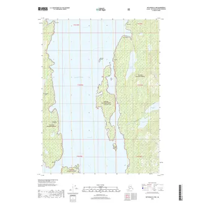
2018 Map of Ketchikan B-3 NW
USGS Topo · Published 2018About this map
Winstanley Island sits at the center of this coastal survey, flanked by the deep waters of the Behm Canal and Shoalwater Pass. This portion of the Alexander Archipelago is defined by a complex network of fjords and freshwater systems within the Tongass National Forest. Inland from the shoreline, a chain of glacial water bodies including Checats Lake, Lower Checats Lake, and the Winstanley Lakes dominate the eastern topography. The map illustrates the maritime character of the region, where travel is dictated by coastal landmarks such as Edith Point and Harding Point. Small landmasses like Entrance Island and Candle Island serve as navigational markers in the channels, while the land rises sharply from the sea into the dense forest of Revillagigedo Island.
Find a feature on this map
31 named features on this map. Tap any name to fly to it.
Don’t see what you’re looking for? This feature index may not catch every label — zoom into the map to look around manually.
Map Details
Editions of this 2018 Ketchikan B-3 NW Map
This is the sole edition of this map. No revisions or reprints were ever made.
Other maps of this area

1949 · Ketchikan B-4
USGS Topo · 1:63,360

1952 · Ketchikan
USGS Topo · 1:250,000

1952 · Ketchikan B-4
USGS Topo · 1:63,360

1952 · Ketchikan C-4
USGS Topo · 1:63,360

1955 · Ketchikan C-3
USGS Topo · 1:63,360

1955 · Ketchikan B-3
USGS Topo · 1:63,360

1955 · Ketchikan C-4
USGS Topo · 1:63,360

1955 · Ketchikan
USGS Topo · 1:250,000
1995 · Ketchikan C-4
USGS Topo · 1:63,360
1995 · Ketchikan B-4
USGS Topo · 1:63,360