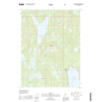
2017 Map of Ketchikan B-4 NE
USGS Topo · Published 2017About this map
Revillagigedo Island presents a complex interior landscape of interconnected waterways and high-elevation basins within the Tongass National Forest. Central to this area is the expansive Ella Lake, which dominates the northern half of the sheet and is fed by Ella Cr. The map reveals a dense network of freshwater bodies, including the Gokachin Lakes, Basin Lake, and Mesa Lake, illustrating the glacial topography typical of Southeast Alaska. Human activity is represented by the Gokachin Trail in the southwest, providing one of the few named overland routes through the timbered terrain. To the southeast, the landscape drops away to meet the salt water at the Gulf of Alaska, marking the transition from the island's mountainous interior to the Pacific coast.
Find a feature on this map
19 named features on this map. Tap any name to fly to it.
Don’t see what you’re looking for? This feature index may not catch every label — zoom into the map to look around manually.
Map Details
Editions of this 2017 Ketchikan B-4 NE Map
This is the sole edition of this map. No revisions or reprints were ever made.
Other maps of this area

1949 · Ketchikan B-4
USGS Topo · 1:63,360

1952 · Ketchikan
USGS Topo · 1:250,000

1952 · Ketchikan B-4
USGS Topo · 1:63,360

1952 · Ketchikan C-4
USGS Topo · 1:63,360

1955 · Ketchikan C-3
USGS Topo · 1:63,360

1955 · Ketchikan B-3
USGS Topo · 1:63,360

1955 · Ketchikan C-4
USGS Topo · 1:63,360

1955 · Ketchikan
USGS Topo · 1:250,000
1995 · Ketchikan C-4
USGS Topo · 1:63,360
1995 · Ketchikan B-4
USGS Topo · 1:63,360