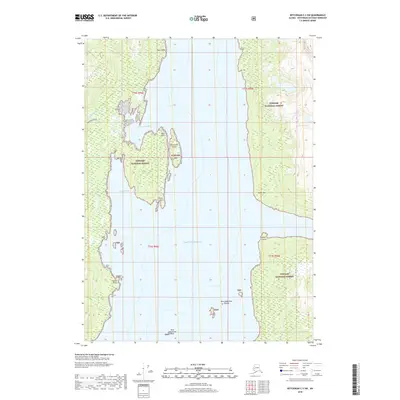
2018 Map of Ketchikan C-3 SW
USGS Topo · Published 2018About this map
Tongass National Forest dominates this coastal landscape, where the intricate shoreline of the Behm Canal meets the Revillagigedo Island interior. This 2018 survey details the transition from the Pacific Ocean into sheltered waters like Manzanita Bay and Sargent Bay. The presence of the New Eddystone Islands and the singular New Eddystone Rock TNF highlights a geologically significant area known for its striking volcanic pillars rising directly from the sea. Inland, the hydrology centers on Manzanita Lake and its tributary, N Fork Manzanita Cr, illustrating the rugged drainage patterns of the Alexander Archipelago. Numerous coastal landmarks, including Cactus Point, Point Louise, and Skirt Point, serve as critical navigational markers for the waterway that defines this portion of the Ketchikan Gateway Borough.
Find a feature on this map
21 named features on this map. Tap any name to fly to it.
Don’t see what you’re looking for? This feature index may not catch every label — zoom into the map to look around manually.
Map Details
Editions of this 2018 Ketchikan C-3 SW Map
This is the sole edition of this map. No revisions or reprints were ever made.
Other maps of this area

1949 · Ketchikan B-4
USGS Topo · 1:63,360

1952 · Ketchikan
USGS Topo · 1:250,000

1952 · Ketchikan B-4
USGS Topo · 1:63,360

1952 · Ketchikan C-4
USGS Topo · 1:63,360

1955 · Ketchikan C-3
USGS Topo · 1:63,360

1955 · Ketchikan B-3
USGS Topo · 1:63,360

1955 · Ketchikan C-4
USGS Topo · 1:63,360

1955 · Ketchikan
USGS Topo · 1:250,000
1995 · Ketchikan C-4
USGS Topo · 1:63,360
1995 · Ketchikan B-4
USGS Topo · 1:63,360