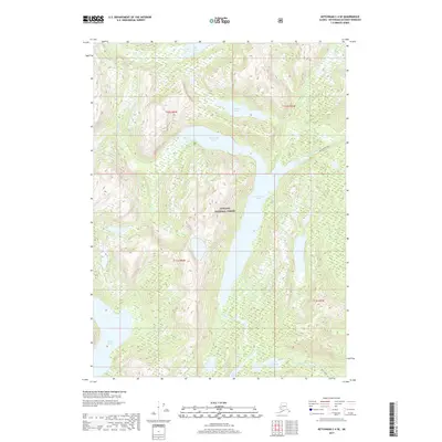
2017 Map of Ketchikan C-4 SE
USGS Topo · Published 2017About this map
Tongass National Forest dominates this Alaskan landscape, where a complex network of glacial lakes and drainage creeks defines the interior of Revillagigedo Island. Large water bodies like the central Manzanita Lake and the southern Ella Lake are primary landmarks, connected by seasonal waterways including Manzanita Cr and Ella Cr. The map reveals a wilderness largely devoid of modern infrastructure, focused instead on the preservation of the natural watershed. Notable smaller features such as January Lake and Lake Grace are tucked into the high-elevation drainages, while Fromholz Cr and Grace Cr carve paths through the timbered terrain. This survey reflects the modern management of one of the nation's most significant temperate rainforests, capturing the hydrologic layout of the region as it existed in the early twenty-first century.
Find a feature on this map
17 named features on this map. Tap any name to fly to it.
Don’t see what you’re looking for? This feature index may not catch every label — zoom into the map to look around manually.
Map Details
Editions of this 2017 Ketchikan C-4 SE Map
This is the sole edition of this map. No revisions or reprints were ever made.
Other maps of this area

1949 · Ketchikan B-4
USGS Topo · 1:63,360

1952 · Ketchikan
USGS Topo · 1:250,000

1952 · Ketchikan B-4
USGS Topo · 1:63,360

1952 · Ketchikan C-4
USGS Topo · 1:63,360

1955 · Ketchikan C-3
USGS Topo · 1:63,360

1955 · Ketchikan B-3
USGS Topo · 1:63,360

1955 · Ketchikan C-4
USGS Topo · 1:63,360

1955 · Ketchikan
USGS Topo · 1:250,000
1995 · Ketchikan C-4
USGS Topo · 1:63,360
1995 · Ketchikan B-4
USGS Topo · 1:63,360