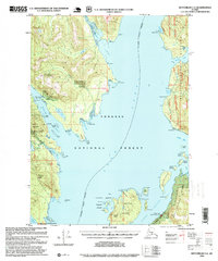
1995 Map of Ketchikan C-6
USGS Topo · Published 1999About this map
The maritime industrial and recreational landscape of the Ketchikan Gateway Borough is defined by the deep waters of the Behm Canal and the rugged topography of the Tongass National Forest. This mid-1990s revision reveals a complex history of resource extraction centered around Gold Mountain, where the Gold Standard Mine, Steers Mine, and Alaska Gold Mountain Mines indicate the area's mineral prospects. Settlement is sparse and largely focused on maritime and wilderness access, with the Boat Dock (Steers) and remote Forest Service outposts like the Helm Creek Cabin (FS) and Helm Bay Cabin (FS) dotting the shoreline.
Find a feature on this map
55 named features on this map. Tap any name to fly to it.
Don’t see what you’re looking for? This feature index may not catch every label — zoom into the map to look around manually.
Map Details
Editions of this 1995 Ketchikan C-6 Map
This is the sole edition of this map. No revisions or reprints were ever made.
Other maps of this area

1948 · Ketchikan C-5
USGS Topo · 1:63,360

1949 · Ketchikan C-6
USGS Topo · 1:63,360

1949 · Craig B-1
USGS Topo · 1:63,360

1949 · Craig D-1
USGS Topo · 1:63,360

1950 · Craig B-1
USGS Topo · 1:63,360

1950 · Craig C-1
USGS Topo · 1:63,360

1951 · Craig C-1
USGS Topo · 1:63,360

1951 · Craig D-1
USGS Topo · 1:63,360

1952 · Ketchikan
USGS Topo · 1:250,000

1952 · Ketchikan C-6
USGS Topo · 1:63,360