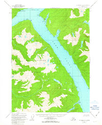
1962 Map of Ketchikan D-4
USGS Topo · Published 1963About this map
Behm Canal serves as the dominant waterway in this mid-century survey of the Alaskan panhandle, separating the mainland from the interior of Revillagigedo Island. This portion of the Tongass National Forest is defined by a complex network of coastal inlets and mountainous drainage systems, where freshwater sources like Saks Lake and Claude Lake feed into the glacial-cut fjords. The maritime geography is documented through detailed coastal markers such as Pt Whaley, Pt Fitzgibbon, and the Center Islets within Fitzgibbon Cove. The mapping of Burroughs Bay includes the Burroughs Bay South Base, reflecting the precision of the U.S. Coast and Geodetic Survey charts used to compile the hydrographic data. This era of mapping shows a landscape primarily influenced by its rugged coastline and the natural drainage of Saks Creek and Orchard Creek, before any significant modern development.
Find a feature on this map
21 named features on this map. Tap any name to fly to it.
Don’t see what you’re looking for? This feature index may not catch every label — zoom into the map to look around manually.
Map Details
Editions of this 1962 Ketchikan D-4 Map
This is the sole edition of this map. No revisions or reprints were ever made.
Other maps of this area

1948 · Ketchikan C-5
USGS Topo · 1:63,360

1951 · Bradfield Canal
USGS Topo · 1:250,000

1952 · Ketchikan
USGS Topo · 1:250,000

1952 · Ketchikan C-4
USGS Topo · 1:63,360

1952 · Ketchikan D-5
USGS Topo · 1:63,360

1953 · Ketchikan C-5
USGS Topo · 1:63,360

1953 · Ketchikan D-5
USGS Topo · 1:63,360

1954 · Bradfield Canal
USGS Topo · 1:250,000

1955 · Ketchikan C-3
USGS Topo · 1:63,360

1955 · Bradfield canal A-4
USGS Topo · 1:63,360