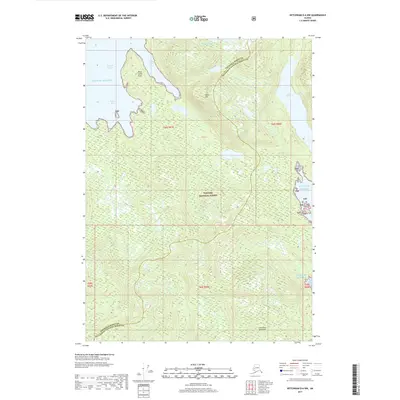
2017 Map of Ketchikan D-6 NW
USGS Topo · Published 2017About this map
Santa Anna Inlet and the Seward Passage carve into the western edge of the Cleveland Peninsula in this 2017 survey of Southeast Alaska. Much of the interior landscape is defined by the dense, protected wilderness of the Tongass National Forest, where a network of freshwater bodies like Lake McDonald, Standing Rock Lake, and Lake Helen are tucked between steep coastal ridges. The terrain rises sharply from the saltwater shores of the Gulf of Alaska at Sunny Bay to the high point at Table Mtn. This sheet captures a remote section of the border between Wrangell Borough and Ketchikan Gateway Borough, illustrating the complex maritime geography and untouched forest characteristic of this region. The lack of road infrastructure emphasizes the reliance on waterways and coastal points like Point Santa Anna for navigation and access to this part of the Alexander Archipelago.
Find a feature on this map
17 named features on this map. Tap any name to fly to it.
Don’t see what you’re looking for? This feature index may not catch every label — zoom into the map to look around manually.
Map Details
Editions of this 2017 Ketchikan D-6 NW Map
This is the sole edition of this map. No revisions or reprints were ever made.
Other maps of this area

1948 · Petersburg A-1
USGS Topo · 1:63,360

1949 · Craig D-1
USGS Topo · 1:63,360

1951 · Bradfield Canal
USGS Topo · 1:250,000

1951 · Craig D-1
USGS Topo · 1:63,360

1951 · Petersburg A-1
USGS Topo · 1:63,360

1952 · Petersburg
USGS Topo · 1:250,000

1952 · Ketchikan
USGS Topo · 1:250,000

1952 · Ketchikan D-6
USGS Topo · 1:63,360

1953 · Ketchikan D-6
USGS Topo · 1:63,360

1954 · Bradfield Canal
USGS Topo · 1:250,000