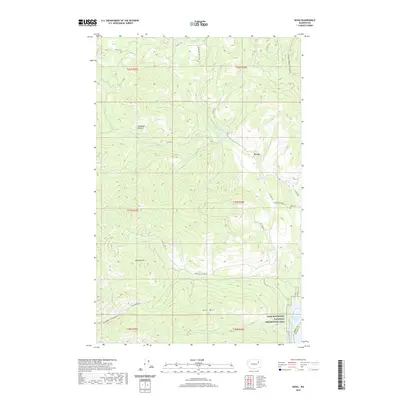
2020 Map of Kewa
USGS Topo · Published 2020About this map
Kewa sits at the heart of this Ferry County landscape, where the high-altitude terrain of the Colville Indian Reservation meets the northern reaches of the Lake Roosevelt National Recreation Area. The geography is defined by a series of steep drainages including Nez Perce Cr and Falls Cr, which flow toward the impounded Columbia River. Local history is anchored by the Kewa Cem and several distinctive named clearings and landmarks like Longhairs Pasture and Seymour Hill. The map detail shows a network of remote access roads such as Bia RD 81 and Twin Lakes Meteor Rd, reflecting the complex management of tribal lands and forest resources in this corner of Washington. The transition from the high peaks of Mid Mtn down to the shores of Franklin D Roosevelt Lake illustrates the dramatic elevation shifts typical of the region's topography.
Find a feature on this map
34 named features on this map. Tap any name to fly to it.
Don’t see what you’re looking for? This feature index may not catch every label — zoom into the map to look around manually.
Map Details
Editions of this 2020 Kewa Map
This is the sole edition of this map. No revisions or reprints were ever made.
Other maps of this area

1948 · Hunters
USGS Topo · 1:62,500

1948 · Wilmont Creek
USGS Topo · 1:62,500

1950 · Wilmont Creek
USGS Topo · 1:62,500

1950 · Hunters
USGS Topo · 1:62,500

1950 · Inchelium
USGS Topo · 1:62,500

1952 · Twin Lakes
USGS Topo · 1:62,500

1954 · Okanogan
USGS Topo · 1:250,000

1956 · Wilmont Creek
USGS Topo · 1:62,500

1958 · Okanogan
USGS Topo · 1:250,000

1984 · Nespelem
USGS Topo · 1:100,000