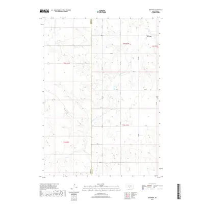
2017 Map of Keyapaha
USGS Topo · Published 2017About this map
Sand Creek winds through the rolling landscape of south-central South Dakota, crossing between the Todd County and Tripp County boundary lines. The map captures the agricultural and prairie layout of the late 2010s, defined by a rigid section grid of rural roads including 296th St and 300th Ave. The small settlement of Keyapaha sits in the northeastern portion of the sheet, serving as a focal point for the surrounding ranching community. Further south along 302nd Ave, the Linden Pioneer Cem provides a specific point of interest for genealogists tracing early families in this corner of the state. The landscape is characterized by its drainage patterns into the creek and a network of local connectors like C R 125 that link these isolated homesteads and burial grounds.
Find a feature on this map
22 named features on this map. Tap any name to fly to it.
Don’t see what you’re looking for? This feature index may not catch every label — zoom into the map to look around manually.
Map Details
Editions of this 2017 Keyapaha Map
This is the sole edition of this map. No revisions or reprints were ever made.
Other maps of this area

1950 · Norden
USGS Topo · 1:62,500

1950 · Sparks
USGS Topo · 1:62,500

1952 · Norden
USGS Topo · 1:62,500

1955 · Martin
USGS Topo · 1:250,000

1957 · Valentine
USGS Topo · 1:250,000

1958 · Martin
USGS Topo · 1:250,000

1959 · Valentine
USGS Topo · 1:250,000

1982 · Keyapaha SE
USGS Topo · 1:24,000
1982 · Clearfield
USGS Topo · 1:24,000

1982 · Hidden Timber SE
USGS Topo · 1:24,000