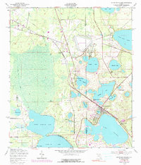
1949 Map of Keystone Heights
USGS Topo · Published 1990About this map
The Georgia Southern and Florida railroad cuts a diagonal path through this lake-rich region of North Central Florida, anchoring the development of Keystone Heights and the small settlement at Theressa. Water dominates the landscape, defined by a dense cluster of basins including Brooklyn Lake, Lake Geneva, and the expansive Little Santa Fe Lake. The map reveals the early layout of Tibbits Park Palms and the recreational draw of Santa Fe Beach at the southern edge. Along the northern boundary, the presence of Camp Blanding and the Wildlife Management Area suggests a landscape transitioning from active military use to conservation. Aviation history is noted at the Keystone Airpark, while various cemeteries and local landmarks like Lake Bedford Camp offer specific points of interest for genealogists and local historians.
Find a feature on this map
37 named features on this map. Tap any name to fly to it.
Don’t see what you’re looking for? This feature index may not catch every label — zoom into the map to look around manually.
Map Details
Editions of this 1949 Keystone Heights Map
4 editions found
Other maps of this area

1915 · Interlachen
USGS Topo · 1:48,000

1916 · Interlachen
USGS Topo · 1:62,500

1938 · Hawthorn
USGS Topo · 1:48,000

1941 · Starke
USGS Topo · 1:62,500

1942 · Ates Creek
USGS Topo · 1:62,500

1943 · Hawthorn
USGS Topo · 1:62,500

1944 · Interlachen
USGS Topo · 1:62,500

1948 · Starke
USGS Topo · 1:50,000

1949 · Sampson
USGS Topo · 1:24,000

1949 · Gold Head Branch
USGS Topo · 1:24,000