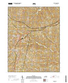
2019 Map of Keysville
USGS Topo · Published 2019About this map
Keysville serves as the central hub for this portion of Southside Virginia, situated at the intersection of Charlotte, Prince Edward, and Lunenburg counties. The landscape is defined by the headwaters of the N Meherrin River and its numerous tributaries, including Ash Camp Cr and Gills Cr. Local history is preserved in several notable burial grounds such as Ash Camp Memorial Cem and Mount Ellis Cem, which lie near the town center, while Staples Cem sits further east. Small settlements like Briery, Simplicity, and Virso are scattered across the drainage basins of the Bush River and Spring Cr. The town's water infrastructure is highlighted by the Keysville Reservoir and Four Locusts Lake, illustrating the community's reliance on managed water resources amidst the area's many creeks and branches.
Find a feature on this map
103 named features on this map. Tap any name to fly to it.
Don’t see what you’re looking for? This feature index may not catch every label — zoom into the map to look around manually.
Map Details
Editions of this 2019 Keysville Map
This is the sole edition of this map. No revisions or reprints were ever made.
Other maps of this area

1891 · Farmville
USGS Topo · 1:125,000

1892 · Appomattox
USGS Topo · 1:125,000

1893 · Farmville
USGS Topo · 1:125,000

1947 · Roanoke
USGS Topo · 1:250,000

1953 · Greensboro
USGS Topo · 1:250,000

1954 · Greensboro
USGS Topo · 1:250,000

1954 · Clover
USGS Topo · 1:62,500

1955 · Chase City
USGS Topo · 1:62,500

1956 · Charlotte Court House
USGS Topo · 1:62,500

1958 · Keysville
USGS Topo · 1:62,500