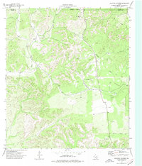
1974 Map of Kickapoo Caverns
USGS Topo · Published 1977About this map
Kickapoo Caverns sits near the northern boundary of this Texas landscape where the Edwards and Kinney county lines meet. The terrain is defined by the drainage systems of the East Fork Sycamore Creek and Griffin Creek, leading toward the West Nueces River at the eastern edge. This mid-1970s survey illustrates a region largely focused on resource management and ranching infrastructure, evidenced by the scattered presence of a Water Tank, a remote Landing Strip, and a Drill Hole. A prominent Jeep Trail and a Radio Tower suggest the sparse but necessary connectivity and communication required in this transition between the Edwards Plateau and the Rio Grande basin. The map captures the quiet character of the South Texas brush country before the expansion of modern recreational access to the local caverns.
Find a feature on this map
14 named features on this map. Tap any name to fly to it.
Don’t see what you’re looking for? This feature index may not catch every label — zoom into the map to look around manually.
Map Details
Editions of this 1974 Kickapoo Caverns Map
This is the sole edition of this map. No revisions or reprints were ever made.
Other maps of this area

1893 · Nueces
USGS Topo · 1:125,000

1896 · Nueces
USGS Topo · 1:125,000

1896 · Brackett
USGS Topo · 1:125,000

1897 · Brackett
USGS Topo · 1:125,000

1941 · Standart
USGS Topo · 1:62,500

1943 · Standart
USGS Topo · 1:62,500

1944 · Flat Rock
USGS Topo · 1:62,500

1944 · Brackettville
USGS Topo · 1:62,500

1944 · Indian Mountain
USGS Topo · 1:62,500

1958 · Del Rio
USGS Topo · 1:250,000