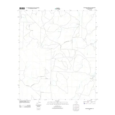
2012 Map of Kickapoo Spring
USGS Topo · Published 2012About this map
Kickapoo Spring and Rust Spring anchor the southeastern and northeastern corners of this Tom Green County landscape, signaling the critical importance of water sources in this ranching country. The 2012 survey illustrates a sparse but deliberate network of private and public roads, such as School House Road Private and Fort McKavett Rd, which connect large, family-named landholdings. Notable operations like the Barron Ranch, Joe Mertz Ranch, and James Barron Ranch occupy broad territories defined by seasonal waterways. These drainages, including Kickapoo Cr, Hog Marsh Cr, and Welch Cr, follow the natural contours of the land, dictating the placement of ranch infrastructure and the orientation of the surrounding rangeland.
Find a feature on this map
20 named features on this map. Tap any name to fly to it.
Don’t see what you’re looking for? This feature index may not catch every label — zoom into the map to look around manually.
Map Details
Editions of this 2012 Kickapoo Spring Map
This is the sole edition of this map. No revisions or reprints were ever made.
Other maps of this area

1892 · San Angelo
USGS Topo · 1:125,000

1928 · Wall
USGS Topo · 1:62,500

1954 · San Angelo
USGS Topo · 1:250,000

1957 · Eola
USGS Topo · 1:62,500

1957 · Wall
USGS Topo · 1:62,500

1958 · San Angelo
USGS Topo · 1:250,000

1965 · San Angelo
USGS Topo · 1:250,000

1970 · Rocking Chair Ranch
USGS Topo · 1:24,000
1970 · Burr Oak Creek
USGS Topo · 1:24,000
1970 · Del Venado Ranch
USGS Topo · 1:24,000