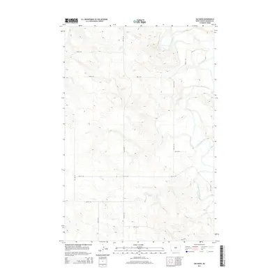
2014 Map of Kid Creek
USGS Topo · Published 2014About this map
The Little Missouri River meanders across the eastern portion of this landscape in Bowman County, shaping the drainage patterns for the surrounding high plains. Flowing into it from the west, Kid Cr carves a series of winding draws through the terrain, highlighting the transition from upland plateaus to the river valley. This part of southwestern North Dakota is defined by a sparse but regular network of section-line roads, such as 172nd Ave SW and 83rd St SW, which serve the agricultural and ranching operations of the region. The map documents the relationship between the natural hydrology of the Missouri River basin and the human imprint of the Public Land Survey System, which dictates the straight-edged paths of routes like 170th Ave SW through the otherwise undulating coulees and ridges.
Find a feature on this map
12 named features on this map. Tap any name to fly to it.
Don’t see what you’re looking for? This feature index may not catch every label — zoom into the map to look around manually.
Map Details
Editions of this 2014 Kid Creek Map
This is the sole edition of this map. No revisions or reprints were ever made.
Other maps of this area

1953 · Miles City
USGS Topo · 1:250,000

1953 · Dickinson
USGS Topo · 1:250,000

1957 · Dickinson
USGS Topo · 1:250,000

1957 · Miles City
USGS Topo · 1:250,000

1958 · Miles City
USGS Topo · 1:250,000

1973 · Kid Creek
USGS Topo · 1:24,000

1973 · Cedar Hills
USGS Topo · 1:24,000
1973 · Mud Buttes
USGS Topo · 1:24,000
1973 · Cedar Ridge
USGS Topo · 1:24,000

1980 · Marmarth
USGS Topo · 1:24,000