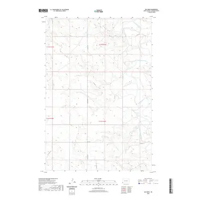
2020 Map of Kid Creek
USGS Topo · Published 2020About this map
The Little Missouri River meanders across this corner of Bowman County, carving a distinct corridor through the North Dakota badlands. The landscape is defined by the drainage patterns of Little Beaver Cr in the northwest and Kid Cr in the south. This area illustrates the intersection of traditional ranching geography with modern industrial utility, visible through a network of specialized access roads. Infrastructure like Oil Well Rd and Oilfield Rd snake through the terrain, supporting local energy extraction while following the natural contours of the land. Established routes such as Camp Crook Rd provide essential connectivity through these township divisions, including t132n r106w and t131n r106w. The map serves as a clear record of how resource management and topography dictate the development of rural Dakota infrastructure.
Find a feature on this map
12 named features on this map. Tap any name to fly to it.
Don’t see what you’re looking for? This feature index may not catch every label — zoom into the map to look around manually.
Map Details
Editions of this 2020 Kid Creek Map
This is the sole edition of this map. No revisions or reprints were ever made.
Other maps of this area

1953 · Miles City
USGS Topo · 1:250,000

1953 · Dickinson
USGS Topo · 1:250,000

1957 · Dickinson
USGS Topo · 1:250,000

1957 · Miles City
USGS Topo · 1:250,000

1958 · Miles City
USGS Topo · 1:250,000

1973 · Kid Creek
USGS Topo · 1:24,000

1973 · Cedar Hills
USGS Topo · 1:24,000
1973 · Mud Buttes
USGS Topo · 1:24,000
1973 · Cedar Ridge
USGS Topo · 1:24,000

1980 · Marmarth
USGS Topo · 1:24,000