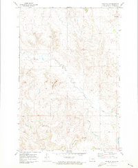
1971 Map of Kiefer Buttes
USGS Topo · Published 1973About this map
Kiefer Buttes dominate the central landscape of this Emmons County area, surveyed by photogrammetric methods from 1969 aerial photography. The terrain is characterized by a series of prominent rises including Hall Hill and Lookout Butte, which stand as landmarks above the surrounding prairie. This 1971 field-checked map illustrates a sparsely populated agricultural and grazing region where the most significant features are the natural formations and the drainage systems. Cattail Creek meanders through the northern and central sections, while the South Branch and Becker Lake define the southeastern corner. The absence of established towns or rail lines emphasizes the rural, open-range character of this part of North Dakota in the early 1970s, making it a valuable record of the physical geography and land divisions defined by the section lines of Township 130 North.
Find a feature on this map
11 named features on this map. Tap any name to fly to it.
Don’t see what you’re looking for? This feature index may not catch every label — zoom into the map to look around manually.
Map Details
Editions of this 1971 Kiefer Buttes Map
This is the sole edition of this map. No revisions or reprints were ever made.
Other maps of this area

1953 · McIntosh
USGS Topo · 1:250,000

1954 · Bismarck
USGS Topo · 1:250,000

1958 · Bismarck
USGS Topo · 1:250,000

1958 · McIntosh
USGS Topo · 1:250,000

1965 · Pollock
USGS Topo · 1:24,000

1966 · Mahto NE
USGS Topo · 1:24,000

1966 · Pollock NW
USGS Topo · 1:24,000

1968 · Fort Yates SE
USGS Topo · 1:24,000

1968 · Fort Yates NE
USGS Topo · 1:24,000

1971 · Grassna NW
USGS Topo · 1:24,000