
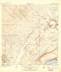
1921 Map of Kilauea
USGS Topo · Published 1954About this map
Hawaii National Park and its surrounding forest reserves dominate this early twentieth-century survey of the Big Island's volcanic heart. The landscape is a complex network of active geology and early colonial infrastructure, centered on the Kilauea crater and the fiery pit of Halemaumau. Near the crater rim, human presence is established through the Volcano House, the Kilauea Museum, and the Kilauea Military Camp. To the west and south, the Kau Desert and various lava flows are crisscrossed by historic routes like the Old Kau-Volcano Trail and the Old Puna-Kau Trail.
Find a feature on this map
106 named features on this map. Tap any name to fly to it.
Don’t see what you’re looking for? This feature index may not catch every label — zoom into the map to look around manually.
Map Details
Editions of this 1921 Kilauea Map
2 editions found
Other maps of this area

1917 · Hilo
USGS Topo · 1:62,500

1922 · Puna
USGS Topo · 1:62,500

1923 · Pahala
USGS Topo · 1:62,500

1924 · Kilauea
USGS Topo · 1:62,500

1924 · Puna
USGS Topo · 1:62,500

1924 · Honuapo
USGS Topo · 1:62,500

1927 · Kaohe
USGS Topo · 1:62,500

1928 · Mauna Loa
USGS Topo · 1:62,500

1930 · Humuula
USGS Topo · 1:62,500

1930 · Kaohe
USGS Topo · 1:62,500