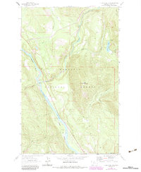
1963 Map of Kilbrennan Lake
USGS Topo · Published 1984About this map
The Yaak River flows through the heart of the Kootenai National Forest in this topographic record, which captures the intersection of industrial transport and mountain wilderness. Along the river's western bank, the Burlington Northern railroad serves as the primary corridor for commerce through the steep terrain, passing by small outposts like Pine and Yakt. The landscape is dominated by the massive profile of Yaak Mountain, which rises sharply between the river valley and the drainages of O'Brien Creek and Ruby Creek.
Find a feature on this map
21 named features on this map. Tap any name to fly to it.
Don’t see what you’re looking for? This feature index may not catch every label — zoom into the map to look around manually.
Map Details
Editions of this 1963 Kilbrennan Lake Map
2 editions found
Other maps of this area

1911 · Priest Lake
USGS Topo · 1:250,000

1913 · Priest Lake
USGS Topo · 1:250,000

1920 · Libby
USGS Topo · 1:125,000

1930 · Libby
USGS Topo · 1:125,000

1932 · Libby
USGS Topo · 1:125,000

1951 · Mt Pend Oreille
USGS Topo · 1:62,500

1957 · Kalispell
USGS Topo · 1:250,000

1958 · Sandpoint
USGS Topo · 1:250,000

1960 · Kalispell
USGS Topo · 1:250,000

1961 · Kalispell
USGS Topo · 1:250,000