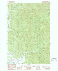
1985 Map of Kilchis River
USGS Topo · Published 1985About this map
Kilchis River and the Miami River dominate this coastal landscape, winding through the heavily forested reaches of the Tillamook State Forest. In the mid-1980s, the lower reaches of these river systems transitioned from the timber-rich hills into the marshy lowlands near Tillamook Bay. Along the southern margin, the settlements of Bay City and Idaville mark the intersection of coastal transit and local recreation, with landmarks like the Drive in Theater and a local golf course situating the era's social life.
Find a feature on this map
38 named features on this map. Tap any name to fly to it.
Don’t see what you’re looking for? This feature index may not catch every label — zoom into the map to look around manually.
Map Details
Editions of this 1985 Kilchis River Map
This is the sole edition of this map. No revisions or reprints were ever made.
Other maps of this area

1937 · Nehalem
USGS Topo · 1:62,500

1937 · Enright
USGS Topo · 1:62,500

1941 · Enright
USGS Topo · 1:62,500

1942 · Ginger Peak
USGS Topo · 1:62,500

1942 · Tillamook
USGS Topo · 1:62,500

1943 · Nehalem
USGS Topo · 1:62,500

1948 · Vancouver
USGS Topo · 1:250,000

1950 · Vancouver
USGS Topo · 1:250,000

1950 · Vancouver
USGS Topo · 1:250,000

1955 · Blaine
USGS Topo · 1:62,500