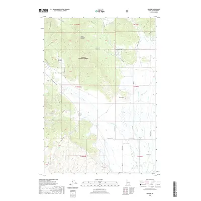
2020 Map of Kilgore
USGS Topo · Published 2020About this map
The settlement of Kilgore sits at the base of the high country in Clark County, where the sprawling Camas Meadows transition into the steep slopes of the Centennial Mountains. This 2020 landscape is defined by the drainage networks of E Camas Creek and W Camas Cr, which flow from the northern peaks toward the lower basin. High-elevation landmarks such as E Camas Table Mtn, Bear Gulch Table Mtn, and the Western Centennial Mountains dominate the northern half of the quadrangle within the Targhee National Forest.
Find a feature on this map
70 named features on this map. Tap any name to fly to it.
Don’t see what you’re looking for? This feature index may not catch every label — zoom into the map to look around manually.
Map Details
Editions of this 2020 Kilgore Map
This is the sole edition of this map. No revisions or reprints were ever made.
Other maps of this area

1950 · Lower Red Rock Lake
USGS Topo · 1:62,500

1955 · Dubois
USGS Topo · 1:250,000

1955 · Ashton
USGS Topo · 1:250,000

1958 · Dubois
USGS Topo · 1:250,000

1958 · Ashton
USGS Topo · 1:250,000

1960 · Ashton
USGS Topo · 1:250,000

1968 · Big Table Mountain
USGS Topo · 1:24,000

1972 · Pine Butte
USGS Topo · 1:24,000

1972 · Antelope Valley
USGS Topo · 1:24,000

1972 · Kilgore
USGS Topo · 1:24,000