
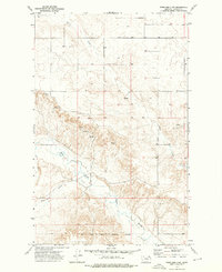
1973 Map of Killenbeck Reservoir
USGS Topo · Published 1976About this map
Killenbeck Reservoir and the winding drainage of Butte Creek anchor this agricultural landscape in northeastern Montana. Surveyed in the early 1970s, the map reveals a remote prairie economy defined by long-distance rail transport and dispersed grain infrastructure, evidenced by numerous Storage Bins scattered across the township lines. The Burlington Northern railroad cuts a diagonal path through the southern half of the quadrangle, following the natural contours near Spring Coulee. The topography is dominated by dramatic relief features like the Four Buttes in the east and deeply carved seasonal waterways such as Olson Coulee and Brush Creek. This document provides a detailed look at the rural section corners and land use patterns of Daniels County before modern consolidation altered many of these smaller homestead sites.
Find a feature on this map
11 named features on this map. Tap any name to fly to it.
Don’t see what you’re looking for? This feature index may not catch every label — zoom into the map to look around manually.
Map Details
Editions of this 1973 Killenbeck Reservoir Map
This is the sole edition of this map. No revisions or reprints were ever made.
Other maps of this area

1954 · Wolf Point
USGS Topo · 1:250,000

1958 · Wolf Point
USGS Topo · 1:250,000

1973 · Peerless 4 NE
USGS Topo · 1:24,000

1973 · West Fork NE
USGS Topo · 1:24,000

1973 · Peerless
USGS Topo · 1:24,000

1973 · Carbert
USGS Topo · 1:24,000

1973 · Four Buttes NE
USGS Topo · 1:24,000

1973 · Four Buttes
USGS Topo · 1:24,000

1973 · Four Buttes NW
USGS Topo · 1:24,000
1973 · Peerless 4 NW
USGS Topo · 1:24,000