
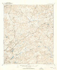
1935 Map of Killian
USGS Topo · Published 1935About this map
Camp Jackson Military Reservation dominates the southern landscape of this mid-1930s survey, a period when the facility was transitioning between its World War I origins and its future role as a permanent infantry training center. To the north, the Sand Hill Experimental Station indicates the region’s agricultural focus on sandy soils. The area is defined by a dense network of country churches and schools, such as Ashbury Ch and Killian Sch, reflecting the rural social structure of Richland County before modern suburbanization.
Find a feature on this map
77 named features on this map. Tap any name to fly to it.
Don’t see what you’re looking for? This feature index may not catch every label — zoom into the map to look around manually.
Map Details
Editions of this 1935 Killian Map
2 editions found
Other maps of this area

1904 · Columbia
USGS Topo · 1:125,000

1935 · Camden
USGS Topo · 1:48,000

1937 · Killian
USGS Topo · 1:62,500

1938 · Camden
USGS Topo · 1:62,500

1938 · Hagood
USGS Topo · 1:62,500

1941 · Spartanburg
USGS Topo · 1:250,000

1942 · Camden
USGS Topo · 1:125,000

1943 · Eastover
USGS Topo · 1:62,500

1944 · Edmund
USGS Topo · 1:62,500

1947 · Columbia North
USGS Topo · 1:24,000