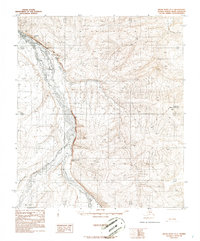
1986 Map of Killik River D-1
USGS Topo · Published 1986About this map
Killik River and the Okokmilaga River dominate this mid-1980s landscape in Alaska's North Slope Borough, where the rivers converge amidst sharp elevation changes and significant geological features. The topographic data reveals a complex drainage system fed by Coal Creek and Ninuluk Creek, cutting through a terrain defined by prominent overlooks such as Kikakpak Bluff and Imnatovik Bluff.
Find a feature on this map
10 named features on this map. Tap any name to fly to it.
Don’t see what you’re looking for? This feature index may not catch every label — zoom into the map to look around manually.
Map Details
Editions of this 1986 Killik River D-1 Map
This is the sole edition of this map. No revisions or reprints were ever made.
Other maps of this area

1951 · Ikpikpuk River
USGS Topo · 1:250,000

1951 · Chandler Lake
USGS Topo · 1:250,000

1951 · Killik River
USGS Topo · 1:250,000

1952 · Umiat
USGS Topo · 1:250,000

1955 · Umiat A-5
USGS Topo · 1:63,360

1956 · Chandler Lake
USGS Topo · 1:250,000

1956 · Killik River
USGS Topo · 1:250,000

1956 · Ikpikpuk River
USGS Topo · 1:250,000

1956 · Umiat
USGS Topo · 1:250,000

1964 · Chandler Lake
USGS Topo · 1:250,000