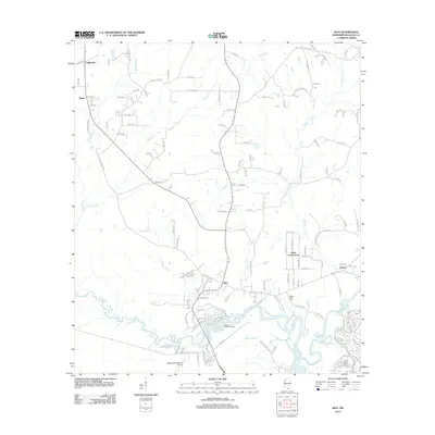
2012 Map of Kiln
USGS Topo · Published 2012About this map
Kiln serves as the focal point of this Hancock County landscape, situated at the confluence of several local routes north of the Jourdan River. The surrounding area is defined by a dense network of coastal waterways and bayous, including Bayou Talla, Mallini Bayou, and Rotten Bayou. To the north and east, small settlements like Catahoula, Wiehe, and Fenton are scattered among the timbered lowlands, connected by numerous unpaved and secondary roads. The southern portion of the sheet reveals the proximity of the Stennis International Airport, while the Bayou Talla Boat Ramp indicates the local importance of river access. Notable for genealogists are several rural burial sites, such as the Bayou Coco Cem and the Little Rotten Bayou Cem, which anchor the local history of these unincorporated communities.
Find a feature on this map
149 named features on this map. Tap any name to fly to it.
Don’t see what you’re looking for? This feature index may not catch every label — zoom into the map to look around manually.
Map Details
Editions of this 2012 Kiln Map
This is the sole edition of this map. No revisions or reprints were ever made.
Other maps of this area

1914 · Nicholson
USGS Topo · 1:62,500

1921 · Nicholson
USGS Topo · 1:62,500

1953 · Mobile
USGS Topo · 1:250,000

1955 · Savannah
USGS Topo · 1:62,500

1956 · Bay St. Louis
USGS Topo · 1:24,000

1956 · Vidalia
USGS Topo · 1:24,000

1956 · Waveland
USGS Topo · 1:24,000

1957 · Mobile
USGS Topo · 1:250,000

1957 · Dead Tiger Creek
USGS Topo · 1:24,000
1958 · Logtown
USGS Topo · 1:24,000