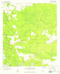
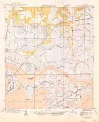
1958 Map of Logtown
USGS Topo · Published 1959About this map
Logtown and Pearlington sit at the edge of a landscape defined by its shifting relationship with the water and the wetlands. This late 1950s survey captures the region along the lower Pearl R and its intricate drainage systems, including Bogue Homa and Whites Bayou. The map reveals a community structured around these waterways and the dense reaches of Devils Swamp. Local life is anchored by family and faith sites like Mt Zion Ch, Spring Branch Ch, and the Logtown Cem. The presence of a Flowing Well and an Oil Well suggests the ongoing extraction and resource-based economy of Hancock County during this era, while the Westonia Lookout provides a literal vantage point over the timber-rich lowlands.
Find a feature on this map
18 named features on this map. Tap any name to fly to it.
Don’t see what you’re looking for? This feature index may not catch every label — zoom into the map to look around manually.
Map Details
Editions of this 1958 Logtown Map
4 editions found
Other maps of this area

1893 · Rigolets
USGS Topo · 1:62,500

1893 · Toulme
USGS Topo · 1:62,500

1914 · Nicholson
USGS Topo · 1:62,500

1921 · Nicholson
USGS Topo · 1:62,500

1935 · English Lookout
USGS Topo · 1:31,680

1935 · Grand Island Pass
USGS Topo · 1:31,680

1936 · Rigolets
USGS Topo · 1:62,500

1941 · Honey Island
USGS Topo · 1:31,680
1946 · Rigolets
USGS Topo · 1:31,680

1949 · Grand Island Pass
USGS Topo · 1:31,680