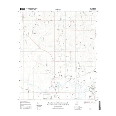
2015 Map of Kiln
USGS Topo · Published 2015About this map
Stennis International Airport and the surrounding piney woods of Hancock County dominate this 2015 survey, illustrating the convergence of modern aviation infrastructure with the intricate hydrology of the Gulf Coast. The town of Kiln serves as a central hub, where the Jourdan River and Bayou Talla meet amidst a network of rural routes like Kiln-Picayune Rd and Cuevas Rd. To the east, the planned community of Diamondhead shows a contrasting high-density street pattern near Rotten Bayou. Family history and local heritage are anchored by small communities such as Catahoula, Wiehe, and Fenton, alongside traditional burial sites including Bayou Coco Cem and Little Rotten Bayou Cem. The map's detail of bayous like Mallini Bayou and Bayou La Terre reveals the low-lying, water-braided landscape that defines this region of Mississippi.
Find a feature on this map
89 named features on this map. Tap any name to fly to it.
Don’t see what you’re looking for? This feature index may not catch every label — zoom into the map to look around manually.
Map Details
Editions of this 2015 Kiln Map
This is the sole edition of this map. No revisions or reprints were ever made.
Other maps of this area

1914 · Nicholson
USGS Topo · 1:62,500

1921 · Nicholson
USGS Topo · 1:62,500

1953 · Mobile
USGS Topo · 1:250,000

1955 · Savannah
USGS Topo · 1:62,500

1956 · Bay St. Louis
USGS Topo · 1:24,000

1956 · Vidalia
USGS Topo · 1:24,000

1956 · Waveland
USGS Topo · 1:24,000

1957 · Mobile
USGS Topo · 1:250,000

1957 · Dead Tiger Creek
USGS Topo · 1:24,000
1958 · Logtown
USGS Topo · 1:24,000