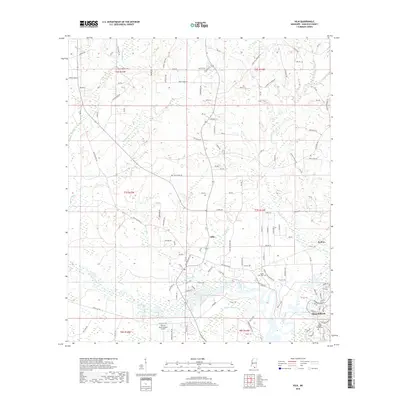
2018 Map of Kiln
USGS Topo · Published 2018About this map
Kiln and Fenton anchor the landscape of Hancock County in this 2018 survey, where the winding Jourdan River meets an intricate network of coastal waterways. The southern portion of the map is defined by the planned community of Diamondhead, situated near the confluence of Mallini Bayou and Rotten Bayou. This area shows a distinct shift from the larger, rural tracts to the north—such as Tract 37 and Tract 38—to the denser residential street grids of the coast. For family historians, several small burial grounds are documented, including the Bayou Coco Cem and Rotten Bayou Cem. Infrastructure is dominated by the Stennis International Airport to the southwest, while numerous bayous like Bayou Talla and Bayou Bacon illustrate the complex drainage patterns of the Mississippi Gulf Coast region.
Find a feature on this map
134 named features on this map. Tap any name to fly to it.
Don’t see what you’re looking for? This feature index may not catch every label — zoom into the map to look around manually.
Map Details
Editions of this 2018 Kiln Map
This is the sole edition of this map. No revisions or reprints were ever made.
Other maps of this area

1914 · Nicholson
USGS Topo · 1:62,500

1921 · Nicholson
USGS Topo · 1:62,500

1953 · Mobile
USGS Topo · 1:250,000

1955 · Savannah
USGS Topo · 1:62,500

1956 · Bay St. Louis
USGS Topo · 1:24,000

1956 · Vidalia
USGS Topo · 1:24,000

1956 · Waveland
USGS Topo · 1:24,000

1957 · Mobile
USGS Topo · 1:250,000

1957 · Dead Tiger Creek
USGS Topo · 1:24,000
1958 · Logtown
USGS Topo · 1:24,000