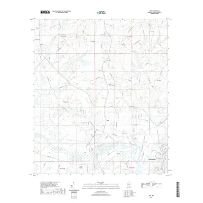
2020 Map of Kiln
USGS Topo · Published 2020About this map
Kiln serves as the central hub of this Hancock County landscape, situated where the terrain begins to give way to the intricate wetlands of the Mississippi Gulf Coast region. The area is defined by a dense network of winding waterways, including Bayou Talla, Bayou Bacon, and the broad Jourdan River, which flows toward the southeastern corner near the developed community of Diamondhead. These watercourses dictate the historical settlement patterns, with roads like Kiln Delisle Rd and Firetower Rd navigating the higher ground between the bayous.
Find a feature on this map
130 named features on this map. Tap any name to fly to it.
Don’t see what you’re looking for? This feature index may not catch every label — zoom into the map to look around manually.
Map Details
Editions of this 2020 Kiln Map
This is the sole edition of this map. No revisions or reprints were ever made.
Other maps of this area

1914 · Nicholson
USGS Topo · 1:62,500

1921 · Nicholson
USGS Topo · 1:62,500

1953 · Mobile
USGS Topo · 1:250,000

1955 · Savannah
USGS Topo · 1:62,500

1956 · Bay St. Louis
USGS Topo · 1:24,000

1956 · Vidalia
USGS Topo · 1:24,000

1956 · Waveland
USGS Topo · 1:24,000

1957 · Mobile
USGS Topo · 1:250,000

1957 · Dead Tiger Creek
USGS Topo · 1:24,000
1958 · Logtown
USGS Topo · 1:24,000