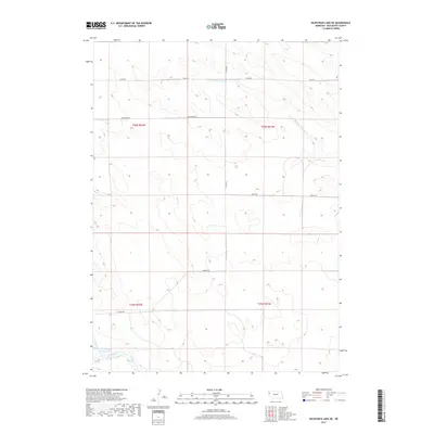
2017 Map of Kilpatrick Lake NE
USGS Topo · Published 2017About this map
Cook NW Reservoir and the headwaters of the Snake Creek system dominate the southern reaches of this Box Butte County landscape. The 2017 survey shows a region defined by its hydrology and section-line road network, where the N Br Snake Creek and S Br Point of Rocks Creek cut subtle drainage patterns across the high plains. This map documents the precise rural grid and water management features essential to Nebraska’s Panhandle agriculture. The transition between Township 25 North and Township 26 North is marked by a steady succession of east-west connectors including Lincoln Rd, Keith Rd, and Hayes Rd, which facilitate movement between the scattered ranching and farming operations. The presence of named reservoirs like the Cook NW Reservoir indicates the critical role of surface water storage in this semi-arid prairie environment.
Find a feature on this map
13 named features on this map. Tap any name to fly to it.
Don’t see what you’re looking for? This feature index may not catch every label — zoom into the map to look around manually.
Map Details
Editions of this 2017 Kilpatrick Lake NE Map
This is the sole edition of this map. No revisions or reprints were ever made.
Other maps of this area

1946 · Nonpareil
USGS Topo · 1:24,000

1948 · Hemingford 4 SW
USGS Topo · 1:24,000

1948 · Hemingford 4 NW
USGS Topo · 1:24,000

1948 · Nonpareil
USGS Topo · 1:24,000

1951 · Marsland
USGS Topo · 1:62,500

1951 · Kilpatrick Lake
USGS Topo · 1:62,500

1955 · Alliance
USGS Topo · 1:250,000

1957 · Alliance
USGS Topo · 1:250,000

1958 · Alliance
USGS Topo · 1:250,000
1983 · Marsland SE
USGS Topo · 1:24,000