
1983 Map of Kilpatrick Lake NE
USGS Topo · Published 1984About this map
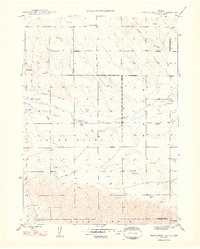
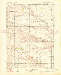
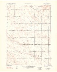
Uhrig Ranch and Bauer Ranch anchor this corner of the Nebraska panhandle in the early 1980s, illustrating the enduring agricultural patterns of the High Plains. The landscape is defined by the ephemeral drainages of South Branch Point Rocks Creek in the north and Snake Creek to the south, separated by the prominent topographic rise of Point Rocks. The widespread distribution of numerous irrigation wells, labeled simply as Irr Well, underscores the transition to groundwater-dependent ranching and farming in Box Butte County. This provisional survey captures the spatial organization of private land holdings and water infrastructure just as modern center-pivot irrigation was becoming a dominant feature of the local rural economy.
Find a feature on this map
8 named features on this map. Tap any name to fly to it.
Don’t see what you’re looking for? This feature index may not catch every label — zoom into the map to look around manually.
Map Details
Editions of this 1983 Kilpatrick Lake NE Map
This is the sole edition of this map. No revisions or reprints were ever made.
Other maps of this area

1946 · Nonpareil
USGS Topo · 1:24,000
1948 · Hemingford 4 SW
USGS Topo · 1:24,000
1948 · Hemingford 4 NW
USGS Topo · 1:24,000
1948 · Nonpareil
USGS Topo · 1:24,000

1951 · Marsland
USGS Topo · 1:62,500

1951 · Kilpatrick Lake
USGS Topo · 1:62,500

1955 · Alliance
USGS Topo · 1:250,000

1957 · Alliance
USGS Topo · 1:250,000

1958 · Alliance
USGS Topo · 1:250,000

1983 · Marsland SE
USGS Topo · 1:24,000