1973 Map of Kimball 1 SW
USGS Topo · Published 1975About this map
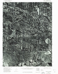
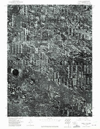
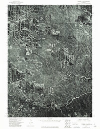
Lodgepole Creek winds through this High Plains landscape, following a sinuous path across the southern half of the quadrangle. Captured via orthophoto imagery in the early 1970s, the map reveals the stark geometry of agricultural development in Kimball County, where rectangular fields and center-pivot irrigation patterns contrast with the organic drainage of the creek bed. Near the southeastern corner, Bennett Reservoir serves as a prominent water management feature, critical for the region's ranching and farming operations. The orthophotomosaic format, prepared by the Department of the Interior and the Geological Survey, provides an unvarnished look at land use and vegetation distribution, showing the fine details of rural access roads and field boundaries that standard topographic line maps often generalize.
Find a feature on this map
2 named features on this map. Tap any name to fly to it.
Don’t see what you’re looking for? This feature index may not catch every label — zoom into the map to look around manually.
Map Details
Editions of this 1973 Kimball 1 SW Map
This is the sole edition of this map. No revisions or reprints were ever made.
Other maps of this area

1954 · Scottsbluff
USGS Topo · 1:250,000

1958 · Scottsbluff
USGS Topo · 1:250,000
1972 · Owasco
USGS Topo · 1:24,000
1972 · Kimball
USGS Topo · 1:24,000
1972 · Oliver Reservoir
USGS Topo · 1:24,000

1973 · Kimball 2 NE
USGS Topo · 1:24,000
1973 · Kimball 2 SE
USGS Topo · 1:24,000

1973 · Kimball 1 SE
USGS Topo · 1:24,000
1973 · Kimball 1 NE
USGS Topo · 1:24,000

1973 · Kimball 1 NW
USGS Topo · 1:24,000