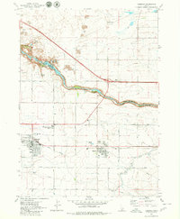
1979 Map of Kimberly
USGS Topo · Published 1980About this map
The Snake River carves a deep, dramatic path across this Idaho landscape, separating the plains of Jerome and Twin Falls counties. Along its northern rim, geological wonders like Devils Corral and Clay Caves define the basalt-rich terrain, while the river itself features several notable points including Twin Falls, Box Canyon, and Vineyard Lake. A Gaging Station and Powerhouse mark the industrial utility of the canyon's descent.
Find a feature on this map
33 named features on this map. Tap any name to fly to it.
Don’t see what you’re looking for? This feature index may not catch every label — zoom into the map to look around manually.
Map Details
Editions of this 1979 Kimberly Map
This is the sole edition of this map. No revisions or reprints were ever made.
Other maps of this area

1955 · Twin Falls
USGS Topo · 1:250,000

1958 · Twin Falls
USGS Topo · 1:250,000

1964 · Kimberly
USGS Topo · 1:24,000

1964 · Falls City
USGS Topo · 1:24,000

1964 · Twin Falls
USGS Topo · 1:24,000

1964 · Eden
USGS Topo · 1:24,000

1964 · Perrine
USGS Topo · 1:24,000

1964 · Hunt
USGS Topo · 1:24,000

1965 · Stricker Butte
USGS Topo · 1:24,000

1965 · Hub Butte
USGS Topo · 1:24,000