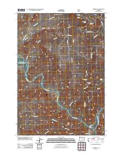
2011 Map of Kimberly
USGS Topo · Published 2011About this map
The confluence of the North Fork John Day River and the main John Day River defines this central Oregon landscape, where the small settlement of Kimberly serves as the primary focal point. Situated in a narrow valley, the town is anchored by the Kimberly Post Office, positioned just north of Johnson Creek. The terrain is characterized by dramatic elevations and deeply cut drainages, including West Bologna Canyon and East Bologna Canyon which feed into Bologna Creek. High points such as China Hat Peak and Tamarack Mountain, which is topped by the Tamarack Lookout, dominate the northern and southern horizons. A network of creeks like China Hat Creek, Balm Creek, and Ives Creek provide a detailed look at the local watershed. This 2011 survey by the U.S. Geological Survey documents the rural infrastructure and natural features of Grant County, from isolated springs like White House Spring to the winding path of Bologna Rd.
Find a feature on this map
22 named features on this map. Tap any name to fly to it.
Don’t see what you’re looking for? This feature index may not catch every label — zoom into the map to look around manually.
Map Details
Editions of this 2011 Kimberly Map
This is the sole edition of this map. No revisions or reprints were ever made.
Other maps of this area

1953 · Richmond
USGS Topo · 1:62,500

1953 · Kimberly
USGS Topo · 1:62,500

1953 · Picture
USGS Topo · 1:62,500

1953 · Spray
USGS Topo · 1:62,500

1955 · Canyon City
USGS Topo · 1:250,000

1959 · Canyon City
USGS Topo · 1:250,000

1980 · Monument
USGS Topo · 1:100,000
1990 · Miller Flat
USGS Topo · 1:24,000
1990 · Bologna Basin
USGS Topo · 1:24,000
1990 · Turner Mountain
USGS Topo · 1:24,000